Urban plannings
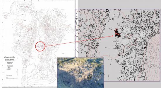
As there is no evidence for a pre-existent grid street layout, the urban planning of Mokisos is not comparable to that of the well-known Roman cities of the antiquity. The peculiar landscape and desire for defensibility seem to determine the urban structure of the town encircled with natural fortifications, in other words the surrounding hills. The town has a dense urban environment comprising about 1000 houses roughly built with local stone and covered with a flat roof or partially vaulted; more than 50 monumental pagan tombs which belong to an earlier Roman necropolis that have subsisted amid the vestiges of 6th century settlement; a fortified acropolis to the north-west hill containing likely military garrison buildings; a heavily damaged ecclesiastical complex in the center of the site, comprising one large and two smaller churches with attached residential buildings, which can possibly be identified as an episcopal residence; two other relatively well-preserved churches on the western slopes of the valley, locally known as Kemerli Kilise and Kara Kilise; and more than 25 other smaller churches all around the town. All these buildings were presumably built in the 6th and 7th centuries, from that period onward the building activity in the town ceased and it seems Mokisos had no political or military importance in later centuries. Only occasional repairs, possibly during 10th and 11th centuries, are visible in a small number of churches, and two Middle Byzantine monasteries outside the site appear to have been built with spolia or reused materials that originated from Mokisos.
Viranşehir presents characteristics of local Anatolian building traditions and regional architectural expressions such as dressed stone masonry, horse-shoe arches and apses, and it stands as a good example of the dramatic changes in Roman urbanism through 4th and 5th centuries. Later Byzantine towns will follow this pattern.
